Enquiry map report
Last updated: January 8, 2026
Pro feature: This feature is available on Pro plans only. If you’d like to upgrade your plan, please contact our support team.
Overview
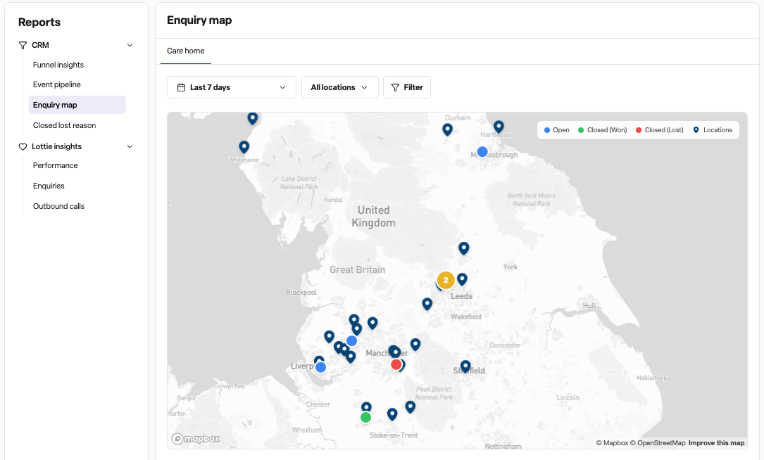
The Enquiry map report is a visual tool that helps you understand where your enquiries are coming from geographically. This interactive map displays enquiries based on the residential postcode of the primary contact associated with each enquiry, making it easy to identify geographical patterns in your referrals and enquiries.
What the map shows
The Enquiry map displays:
Enquiry markers: Coloured circles showing individual enquiries plotted at the contact's residential postcode location
Location markers: Pin icons showing your care home or facility locations
Enquiry status: Different colours indicate whether an enquiry is open, closed (won), or closed (lost)
Clustering: When multiple enquiries are close together, they're automatically grouped into numbered clusters to keep the map readable
Key features
Interactive filtering: Use the standard report filters to narrow down enquiries by date range, location, stage, and other criteria
Click to view details: Click on any enquiry marker to open the full enquiry record, or click a location marker to view the location details
Cluster expansion: Click on a cluster number to zoom in and see individual enquiries, or to "spiderfy" markers when they're at maximum zoom
Information tooltips: Hover over any marker to see a quick summary including the contact name, enquiry status, stage, location, and creation date
Visual legend
The map includes a legend showing:
Blue circles: Open enquiries
Green circles: Closed (won) enquiries
Red circles: Closed (lost) enquiries
Dark blue pins: Your location markers
Frequently asked questions
Q: Where can I find the Enquiry map report?
A: Navigate to the Reports section in Found, then under "CRM" select Enquiry map.
Q: Why are some of my enquiries not showing on the map?
A: The Enquiry map only displays enquiries that have a valid UK postcode recorded in the primary contact's residential address field. Enquiries without this information won't appear on the map. Additionally, the enquiry must be in one of these statuses: Open, Closed (won), or Closed (lost).
Q: What does it mean when I see a number in a circle instead of individual markers?
A: This is called clustering. When multiple enquiries are located close together geographically, they're automatically grouped into a cluster showing the total number of enquiries in that area. Click on the cluster to zoom in and see the individual enquiries.
Q: What happens when I click on a cluster that won't zoom in any further?
A: If you've reached maximum zoom and there are still multiple enquiries at the same location, clicking the cluster will "spiderfy" the markers - spreading them out in a circle pattern so you can see and click on each individual enquiry.
Q: Can I filter the map to show only certain types of enquiries?
A: Yes. The Enquiry map supports all standard CRM report filters including date range, location selection, enquiry stage, source, and custom field filters. Apply filters using the filter panel at the top of the report page.
Q: What information is shown when I hover over an enquiry marker?
A: Hovering over an enquiry marker displays a tooltip with the following information:
Contact name
Enquiry status (Open, Closed won, or Closed lost)
Current enquiry stage
Location name
Date the enquiry was created
Q: Can I see which enquiries are associated with a specific care home?
A: Yes. The map displays both enquiry markers and location markers. You can filter by specific locations using the location filter, and the tooltip on each enquiry marker shows which location it's associated with. Location markers (purple pins) show the physical location of your facilities.
Q: Why does the map show "No valid UK postcodes found"?
A: This message appears when none of the enquiries in your selected filters have valid UK postcodes in the primary contact's residential address. To use this report, ensure your enquiry contacts have their residential postcodes recorded. The geocoding service only works with UK postcodes.
Q: How far back can I view enquiries on the map?
A: You can view enquiries from any date range using the date filter. By default, the report shows enquiries from the last 30 days, but you can adjust this to view historical data or focus on recent activity.
Q: What's the difference between the location pins and the enquiry circles?
A: Location pins (purple markers) represent the physical location of your care homes or facilities. Enquiry circles (blue, green, or red) represent where the enquiry contacts live. This helps you understand the geographical relationship between your referral sources and your facilities.
Q: Can I export the data shown on the map?
A: The Enquiry map is a visual report designed for geographical analysis. To export enquiry data, use the standard enquiry export functionality from the Enquiries section of Found.